So you want to know what orienteering is all about?
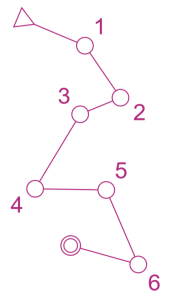 Well….. the basic idea is to navigate your way around a course, most often in the woods, but also in towns, parks and open rugged countryside, using a specially drawn map which shows features such as streams, fences, boulders and crags. You have to start at the Start, finish at the Finish and visit a series of control points along the way, but it’s entirely up to you how you get from point to point and whether you run as fast as you can, or have a gentle stroll and enjoy the outdoors. Most events offer a range of courses, varying by length, physicality, and navigational difficulty, and there is usually a course suitable for everybody, from under 10 year olds to 80 year olds and even older, novice or expert. It is as competitive, as challenging, and as adventurous, as you wish to make it; we cater for everybody at most events. There is often a ‘string’ course for the very small – follow the string through the woods and find the Mr Men.
How can I give it a go?
The easiest way is to come along to any of our events. Newcomers are welcome at all of our events, and there’ll be someone available to help you get started. Event details always provide a phone number or email address via which you can ask about the event, or just let us know you’d like to give orienteering a try, and plan to come along. They also explain how to find the event, and how to enter. We prefer regulars to pre-enter, so that we know how many maps we’ll need, and how many cars we need to accommodate etc, but we also accept entries on the day, so you can just turn up, though it helps if you can let us know that you plan to come, by contacting the event organiser.
If you want to try it out in your own time, you can visit one of our Permanent Orienteering Courses across the county.
Where do events take place?
We hold events all over Gloucestershire: here’s a map of all the areas we use.
The areas vary from the heart of the Forest of Dean, to the open commons of the Cotswolds, to the streets of Cheltenham and Gloucester.
What to bring?
You’ll be glad to hear that there’s very little equipment required:
- Trainers or lightweight boots and tracksuit bottoms or similar that you don’t mind getting a bit muddy
- A compass if you have one for orientating the map. Don’t worry if you don’t: it isn’t essential on beginners courses
- A drink/snack for afterwards
- And a few pounds to pay for your map.
What to expect at your first event….

Having parked, look out for a queue of people by a car or tent waiting to register. You’ll be asked for your name (so we can keep track of who’s out there and the time taken for keen competitors) and which course you want to try. Don’t be afraid to ask advice about which course is the best for you. To begin with try the yellow/orange courses as they are based on tracks or other linear features such as walls. Yellow is suitable for children and less confident adults, while Orange is perfect for more confident adult beginners. Eventually you’ll work up to a light green and beyond where things start to get a bit more technical. You’ll be issued with a map, a set of control descriptions and usually an electronic timing device called a dibber.
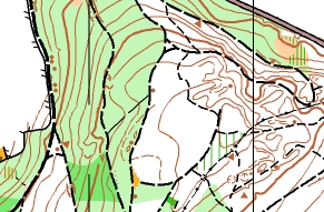 The map … will look a little strange at first with colours and symbols that might as well be hieroglyphics, but you should be able to recognise tracks, paths, streams and contours. You might be somewhat surprised to see that woodland can be white, or various shades of green; the degree of ‘darkness’ indicates runnability, with white woodland easy to run through, and very dark green pretty much impossible to get through! There should be a legend printed down the side to explain the other features but for beginners courses you’ll be using linear features so make sure you know what a track, path, stream, fence and a wall look like and forget about the rest for the time being. The other thing you should note about your map is the scale – most of our events use 1:10,000 scale maps to get the necessary detail in. That means that 1cm on the map represents 100m on the ground. Imagine what the 100m dash looked like on the school playing field and that should help you judge the distance you need to go between controls. Some maps, particularly urban parks use a larger scale, perhaps 1 :5000.
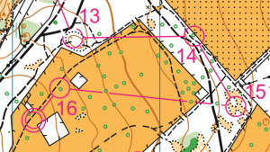
Here’s a sample map extract showing the last 4 controls on a course. Some courses are harder than others and this one is towards the harder end. We have a range of courses at each of our events, as described in the details for each event. Just ask at the event if you’re not sure which to do. But if you really want to know more now, see British Orienteering’s Newcomer’s Guide.
For a full list of symbols used on orienteering maps click here.
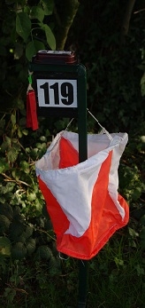 The control descriptions…. will show a list of controls and you must visit them in that order. Control sites are marked by special orange and white “kites” to make them easier to spot at a distance. Each control on the list will have a number or letter code next to it. When you actually reach that control, it will have a code physically attached to it so you know you’ve got the right one. The list also gives a brief description of the feature that you’re looking for, e.g. path/stream junction, fence bend, to help you home in on it once you’re in the right area on the map. Sometimes the descriptions are written in plain English, but at some events, they are in the form of a pictorial code – just ask someone for a translation.
To understand the pictorial descriptions, click here.
The dibber…. should be attached to your finger using the strap. Every time you get to a control, including the Start and Finish, place the dibber into hole on the electronic unit. Make sure that the unit flashes. Before the Start, you will have to clear any previous timing held in your dibber at the Clear station. Again, don’t be afraid to ask for help on the use of these – there is always someone hanging around to help beginners.
Starts…. generally you can start whenever you like after you have registered and got your dibber. However, there will be a last start cutoff time and also a time when all courses close, as obviously the people organising would like to get home sometime the same day! If you want you can leave your car keys at registration before setting off.
Finish…. once you’ve punched the Finish control, go to the download point (often the same place as registration) and hand in your dibber. You will be given your time on a slip of paper which also shows how long it took you between each control. IMPORTANT – Even if you don’t finish your course, you must still go to download to hand in your dibber – this is the only method we have of knowing that you’re back safe and sound and we don’t need to call out International Rescue !
How Do I Get Involved?
The club is entirely run by volunteers. We have no paid staff, and we rely on volunteers for everything, from managing the equipment, running the website, and getting permission to stage events, right through to setting up the entries process, and then planning and organising our events. If you enjoy orienteering and decide to join the club, we are always looking for people to help out at events, and eventually to plan them, or join the committee, and help to ensure the future of the club. Helping out at events is a great way to start; it’s easy to do, there are plenty of people around to give you a hand, and it’s the best way to get to know lots of people in the club. There is no probationary period…..you can start helping the moment you join the club, and will be welcomed with open arms.
Find out more about Volunteering here.
FAQs
What should I wear?
A pair of trainers or lightweight boots and jogging bottoms or similar will do fine to begin with. You might also want to bring a light cagoule if it looks like rain and something to change into afterwards as it can be a bit muddy at any time of year.
Do I need to know how to use a map and compass?
A rough idea of what North is all about should be more than enough. Although we use compasses, we don’t take bearings the same way as hillwalkers do – rather we use the compass to make sure that the map is orientated correctly relative to North as there are special lines on an orienteering map that represent magnetic North. Ask for a lesson on how to do this when you register. A compass is not really necessary for the beginners courses (White, Yellow, Orange).
Who can take part?
Pretty well anybody can take part in normal orienteering events – there is usually a short course of 1km or so on main paths aimed at kids plus a series of courses getting progressively longer and more technical.
Is it really competitive?
Yes and No! If you find that you and orienteering click, you can progress to the level where you compete nationally or even internationally. On the other hand, many of our members are more than happy to take part for the simple pleasure of being outdoors and getting a bit of exercise both physically and mentally.
How much does it cost?
Local events typically cost £5-7 per adult per course or £2 for juniors. If you do not have your own dibber you can hire one for £1-2, or free of charge for juniors, if not using one of the new contactless type dibbers. The larger events cost more (but if you join the club you get a discount.) Entry fees are usually advertised in the event details. If you want to join NGOC then there is a small annual fee – check the Membership page for current fees.
Is it always the same kind of courses described here?
Generally, yes, but there are other variations on the theme such as Night-O, relays or Score events where you have a time limit in which to find as many controls as you can in any order you like. There are long distance events, mountain bike O, park races, street events and Trail-O for people with physical disabilities. These days, we also offer events using the MapRun phone app where there are no actual control flags, but your phone records whether you’ve been to the right place.
Can I practise anywhere else apart from the organised events?
There are a few Permanent Orienteering Courses (POCs) in the area where you can practice any time you wish. We also have a lot of MapRun courses which are permanently available and can be run using the MapRun smartphone app. You can find details on the Permanent Orienteering Courses page
Where can I look up all these new terms and abbreviations I keep coming across?
Like most sports, there is plenty of jargon – British Orienteering jargon buster
