Our Urban and Sprint events are a great way to experience orienteering for the first time.
The maps
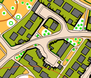
We use detailed maps for these events, at a scale of 1:5000 or 1:4000 (or even 1:2000 at Cheltenham Racecourse!): this is a larger scale than we use for our MapRun courses, so there’s a lot more detail. You’ll see paved areas (tan), open grass (orange), individual trees, and uncrossable features (olive green or black):

The courses
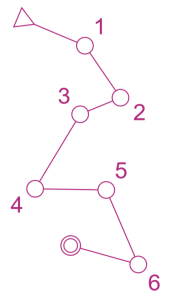
In these events, we’ll have a set of linear courses of different lengths. Unlike the score courses we use for Maprun (where you can visit control points in any order), on linear courses you must visit the control points in a specified order: 1-2-3-4-5-6 in the diagram below:

Between the checkpoints, there’ll be a variety of valid routes to take: your challenge is to find the quickest one! Here’s an example course from one of our previous events.
Visiting control points
We use an SI card, or electronic ‘dibber’, to record visits to control points. There will be a box at each control point with a hole to insert the dibber. It’ll bleep, to let you know it has registered. The newest dibbers are contactless, and you just need to wave them within 30cm of the box to register: both types can be used, and will be available for hire at these events.

